Route Planning Weather for Middle-Mile Lanes
Use route planning weather to set buffers, score risk, and reroute overnight middle-mile lanes before the truck leaves the dock.
November 3, 2026
Over the decade analyzed by the Federal Highway Administration, weather-related conditions accounted for 22% of all U.S. vehicle crashes, approximately 1,259,000 crashes out of an annual average exceeding 5.76 million, producing nearly 6,000 deaths and more than 445,000 injuries per year, according to the Federal Highway Administration road weather chapter. That reframes route planning weather work for overnight middle-mile lanes. It's not checking whether it'll rain. It's deciding, before you promise an arrival, whether pavement, visibility, and wind at the actual driving hour can support that promise without asking a driver to recover lost time.
Condition Buffers Before You Lock an ETA
Don't lock an ETA from a dry-road runtime and then add a vague pad. The Federal Highway Administration weather overview reports that even light rain can increase travel-time delay by 12% to 20%, free-flow speeds can fall 10% to 30% during inclement weather, speed reductions may reach 30% to 40% on snowy or slushy pavement compared with 10% to 25% on wet pavement, and reduced capacity can raise travel delay by as much as 50%. Those bands are your lookup. Match the row to what the pavement and visibility will be at the operating hour, not to what the afternoon looked like in the yard.
Middle-Mile Buffers by Weather Condition
| Condition | Speed or delay effect | Planning buffer | Dispatch action |
|---|---|---|---|
| Light rain | Delay up 12% to 20% | Add 12% to 20% | Keep the lane and watch wet bridges |
| Wet pavement | Speeds down 10% to 25% | High end of the rain band | Recheck grades and bridges |
| General inclement weather | Free-flow speeds down 10% to 30% | Replace the dry-road ETA | Recompute duration before committing |
| Snow or slush | Speeds down 30% to 40% | Add 30% to 40% | Confirm plowing before departure |
| Capacity collapse in bad weather | Delay up to 50% | Up to 50% if speeds collapse | Slip the appointment |
| Fog, ice, wind, or flood | Not a rain percent | Separate score | Use the go or no-go bands |
Start with light rain. If the lane is 2 hours dry, the rain row makes it roughly 2 hours 15 minutes to 2 hours 25 minutes before you add dock time. That's not pessimism, that's arithmetic. You keep the lane, but you stop telling the receiving hub the dry time, and you flag wet bridges and grades where a box truck loses margin first.
Wet pavement pushes you to the high end of that rain band even if active rain has eased. Standing water, spray, and reduced friction don't disappear when the radar clears. If the corridor has short merge ramps, exposed river crossings, or a steep downgrade into a hub, plan at the top of the band and recheck those segments specifically.
For general inclement weather, don't pad the old ETA. Replace it. Recompute segment by segment using the slower speed assumption, because a blanket add-on hides where the loss happens. A lane that's mostly treated interstate with one untreated surface-street leg near the destination loses time in one place, and that's where the appointment fails.
Snow or slush is a different class. Confirm plowing status on the specific corridor, not the metro in general. If plows haven't cycled through the segment the truck will use after midnight, the 30% to 40% band is the starting point, and you may need to move the departure instead of stretching the arrival.
When Capacity Collapses and When Percentages Stop Working
A capacity collapse happens when slowdowns bunch traffic, crashes close lanes, or ramps back up. At that point, protecting the original appointment is the wrong goal. Slip it early. A hub that gets a revised ETA before departure can resequence labor and dock doors. A hub that gets the news 20 minutes before the original time cannot.
Practical rule: The buffer absorbs the slowdown so the driver doesn't have to. If your plan only works when the driver makes time back, you don't have a plan, you have a dry-road estimate with a new label.
Fog, ice, wind, and flood don't share the rain percent. Ice changes traction, not just speed. Wind pushes a high-sided box truck sideways. Fog removes the sight distance you need to use the speed the pavement would otherwise allow. Score those separately and let them override the table.
Consider the Twin Cities overnight case that catches planners most often. At 8 p.m., the lane might show rain, air temperature just above freezing, and manageable speeds. After midnight, pavement temperature can fall below air temperature, bridges freeze first, and that same moisture becomes an ice problem on segments the truck hasn't reached yet. That's why route planning weather decisions must be tied to the arrival hour on each segment.
Before you lock anything, write four fields on the plan.
- Forecast issuance time: Which forecast cycle you used, so stale data is obvious
- Route version: Which corridor and segment times this ETA belongs to
- Selected buffer: The row you applied and why it matches pavement and visibility
- Invalidating condition: The reading that voids this ETA and forces a new review
If you can't fill in the fourth field, you're not ready to promise the arrival.
How to Build a Weather-Aware Lane Plan
Build the plan as a six-step pass on a known lane. It works because Peak Transport driver routes are scheduled routes between facilities, not random residential stops, and they're planned in advance. You're editing a lane you already know, with known handoffs and known dock constraints, not inventing stops under pressure.
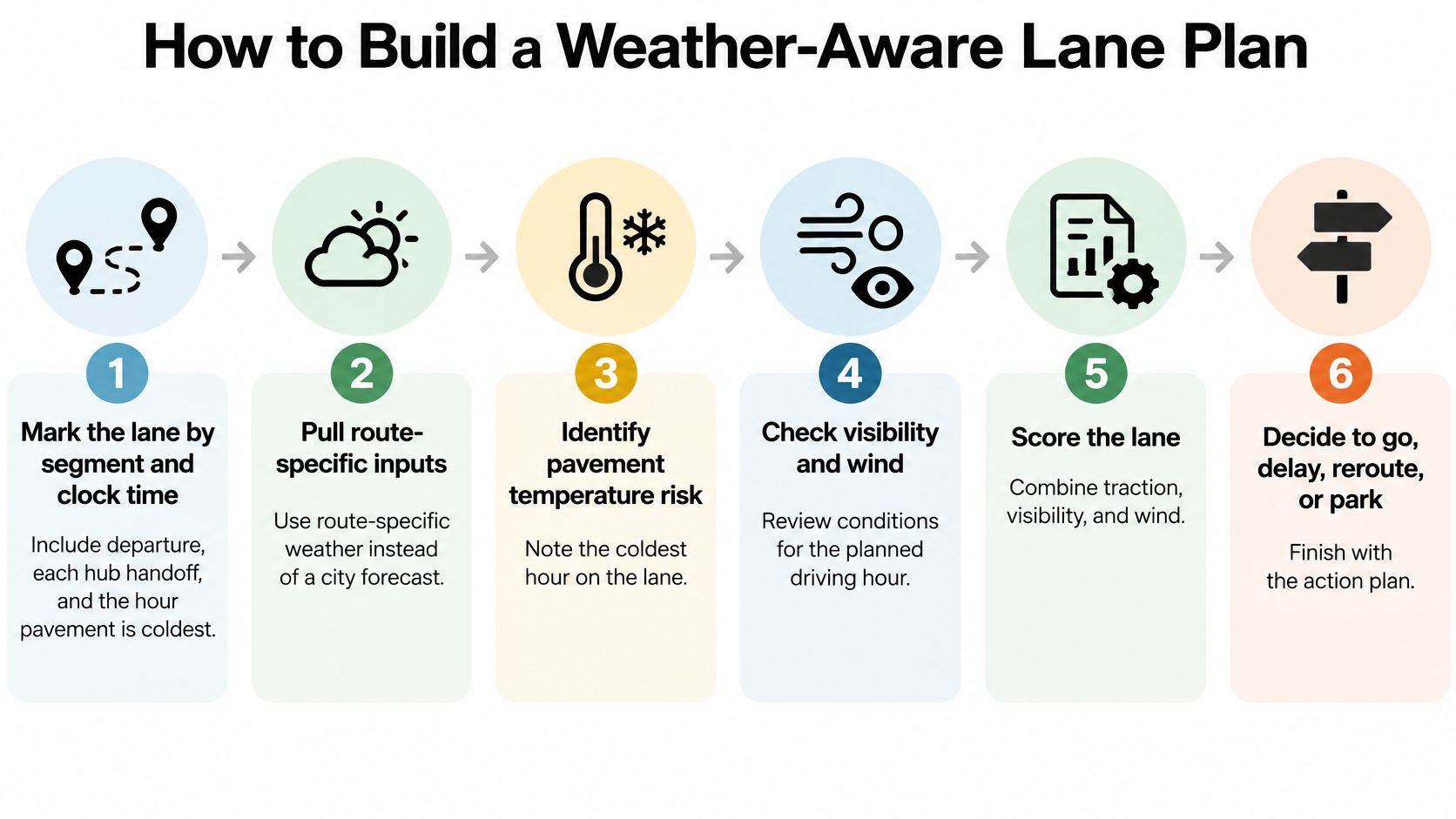
The Six-Step Lane Pass
Mark the lane by segment and clock time. Write down departure, each hub handoff, and the hour when pavement will be coldest on each segment. A lane that leaves at 9 p.m. and reaches a river bridge at 1:30 a.m. needs the 1:30 a.m. condition for that bridge.
Pull route-specific inputs, not a city forecast. Get precipitation type, visibility, wind, pavement temperature, and snow or ice accumulation for the corridor. Use National Weather Service forecasts and warnings, state 511 or road-condition maps, and pavement or RWIS readings where the corridor has them. A city forecast tells you what happens at one point. The lane crosses several microclimates, elevations, and treatment zones before dawn.
Set those readings next to historical segment times for that same hour. Your own carrier lane history is the anchor here. A segment that always slows on wet pavement at 2 a.m. deserves more weight than a generic speed model built from daytime traffic.
Apply the matching buffer row, in priority order. The Federal Highway Administration road weather management one-pager notes that FHWA's regional freight assessment found ice and snow accounted for 49.1% of time lost during large-impact weather events, defined as events associated with speed reductions greater than 10%, followed by wind at 24.9%, rain at 12.4%, and flooding at 12.4%. That's your ranking. Ice and snow get scored first, wind second, rain and flooding next. A modest snow chance outranks heavier rain when pavement temperature sits near freezing, and high wind needs its own review on a high-sided box truck even on dry roads.
Write the trigger that forces action. Name, in advance, the condition that forces a dispatch review, a reroute, a delay notice, or safe parking. "We'll watch it" isn't a trigger. "Freezing precipitation reaches the north segment before the second handoff" is.
Recheck before departure and at each major handoff. If no trigger has tripped, keep the prior version. Don't churn the plan on every forecast update, because drivers and hubs can't execute a plan that changes without a reason.
Weather Data Sources for Each Lane-Pass Step
| Source | What it gives | Used at |
|---|---|---|
| National Weather Service forecasts and warnings | Precipitation type, visibility, wind, freezing risk | Step 2 |
| State 511 or road-condition maps | Plowing status, closures, surface reports | Step 2 |
| Pavement or RWIS readings | Pavement temperature and surface state where installed | Step 2 |
| Carrier lane history | Segment travel times for the same hour | Step 3 |
If you want a useful comparison from another fleet context, this guide to weather planning for building supply fleets shows how route-specific weather tools present conditions along a corridor rather than at a single location. The principle transfers directly to middle-mile work, even though the freight and stops differ.
Don't plan from precipitation probability alone. Probability tells you how likely moisture is. It doesn't tell you whether that moisture lands on warm pavement and runs off, or on a bridge deck at freezing point with a crosswind. Pavement temperature and wind turn a probability into an operating decision.
Close the pass with a log entry that another dispatcher can audit at 3 a.m. without calling you.
- Issuance time: When the forecast you used was published
- Route version: The corridor, segment times, and handoffs in this version
- Assumptions: Precipitation type, treatment status, and visibility you planned against
- Buffer: The condition row you applied
- Voiding reading: The specific change that makes this version invalid
That log is what makes route planning weather a control instead of a conversation. The next person on shift inherits a decision with its reasoning attached.
When to Delay Reroute or Park
Score the lane for the hour the truck will be on the pavement. Four bands are enough. More bands create arguments at midnight. Fewer bands blur the line between "slower" and "unsafe."
Go Delay or Park Bands for an Overnight Lane
| Band | What you see | Action |
|---|---|---|
| Low | Treated pavement, usable visibility, wind inside box-truck limits | Run the planned lane |
| Medium | Rain or wet pavement with no freezing risk | Keep the lane and the rain buffer |
| High | Snow or a forecast speed drop over 10% | Later departure, shorter lane, or treated alternate |
| Stop | Ice, freezing rain, visibility collapse, flood, or unsafe wind | Delay, park, or drop the corridor |
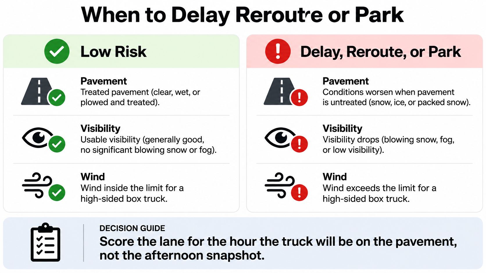
Low means the plan stands as written. Treated pavement, usable visibility, and wind inside the limit for a high-sided box truck. Don't add a buffer you don't need, because padded ETAs that always arrive early train hubs to ignore your times.
Medium means the lane stays and the rain buffer you already chose still applies. This is the band where discipline matters most. Drivers can handle wet pavement with no freezing risk at reduced speed, but only if dispatch doesn't expect the dry arrival anyway.
High means something structural changes before departure. Move the departure later so plows and treatment catch up, shorten the lane by dropping the most exposed leg, or name a treated alternate corridor in advance. I would rather send a truck on a slightly longer interstate with treatment, lighting, fuel, and a place to recover than on the fastest untreated cutoff. The interstate gives the driver options if conditions worsen. The cutoff gives the driver a problem with no exit.
Stop means the corridor doesn't run as planned. Freezing precipitation, ice, visibility collapse, flooding, or wind that makes a box truck unsafe overrides mileage and appointment optimization. Delay it, park the truck at a safe location, or drop that corridor for the cycle.
Why an Early Stop Beats a Midnight Reroute
The safety case for a firm stop band is direct. The Federal Highway Administration road weather and climate change report reports that approximately 13% of commercial-vehicle crashes occur in rain, snow, sleet, hail, or fog, while roughly 16% occur on wet, snow-covered, slushy, or icy pavement, and FHWA freight research found ice and snow associated with over half of travel time lost during weather events, equating to about 12 minutes per truck across the studied areas. NOAA's summary of Midwest and Northeast research covering 11 states and 2008 to 2018 data in that same discussion found each additional hour of lead time on winter-weather advisories reduced daily crashes by nearly 0.75%.
Lead time is the point. A decision made at a fixed predeparture review gives the driver, the origin dock, and the receiving hub the same information at the same time. A reroute invented at midnight gives a tired driver new directions on deteriorating roads. When the band is high or stop, send the revised ETA before wheels roll.
A shorter path through ice isn't a shortcut. It's a crash exposure and a missed handoff wearing the same disguise.
Watch for the common planning errors that push lanes into trouble. A citywide forecast misses corridor-specific pavement conditions. Ignoring wind on a box truck misses the hazard that matters most on exposed bridges. Treating a route as safe because the destination is clear misses the untreated middle segment. Building these bands into your broader logistics risk management approach keeps the weather call consistent with how you handle every other operational risk, instead of leaving it to whoever is on dispatch that night.
Avoid exposed bridges, steep grades, and flood-prone segments first when conditions deteriorate. Preserve legal driving hours for recovery rather than spending them all on the first leg. That's the judgment the bands are designed to protect.
Protect Hours and the Next Run
Once a lane lands in the high or stop band, the question stops being how many miles a detour adds. It becomes how much damage each option does to the rest of the network. Reporting on early-2025 storms summarized by project44's winter storm delivery analysis found average on-time performance declines of 13.8% during one storm and 7.2% during another, with warehouse shutdowns and inbound and outbound delays compounding the road impacts. Labor capacity shrinks at the same time the roads slow, so a reroute that looks cheap on a map can be expensive across the next three runs.
The failure mode is specific. A longer safe corridor still fails if it burns the driver's remaining hours, misses the dock anyway, and knocks out tomorrow's first departure. The objective is the smallest total damage across safety exposure, missed handoffs, detention, and recovery delay. Tonight's travel time is only one line on that ledger.
Controlled Degradation in Order
Work through these five moves in sequence when a lane degrades.
Score the weakest segment before you score the route. The corridor with the worst exposure sets the lane's realistic arrival window. Price the detour against that segment's delay risk, not against the direct line on a clear night.
Hold back enough hours for a local finish. Peak Transport's Middle Mile work is local, so drivers are home after their shift and do no long-haul overnight trips. Keep the plan inside the hours of service rules with margin to spare, because a driver parked out of hours at a far hub turns one weather delay into tomorrow's staffing gap.
Give the hub a number it can hold. An honest revised ETA lets the hub move labor, resequence doors, and warn its outbound lanes once. An optimistic guess forces a second reshuffle when the truck still isn't there at the promised time, and the second reshuffle lands on thinner staffing.
Move freight that can't absorb a miss ahead of freight with slack. Pallets feeding a departure that can't slip outrank freight that can sit a night in the building. Sequence the handoffs by what each miss costs downstream, and say the priority out loud so the dock doesn't guess.
Log what the decision cost. Record miles added, hours preserved, and which appointment moved. That record proves the call was right, and it calibrates the next one.
One Hub Leg Worked Through
A north-metro to south-metro hub leg normally crosses a windy river bridge on the direct corridor. Tonight, gusts on that crossing push the lane into the high band while the treated interstate stays workable. Dispatch moves the truck to the interstate, accepts 20 extra minutes in this scenario, and slips the first dock by one appointment slot. The second hub still makes its window because the interstate leg runs at a predictable speed instead of gambling on the bridge.
The direct route tells the other side. If wind forces a park-up past the crossing, the driver burns hours waiting, misses both appointments, and starts tomorrow short on rest. The interstate costs minutes. The bridge gamble can cost the whole cycle.
The planner's question: Which option does the least damage across the next several trips? The shortest line on the map is the wrong scoreboard.
That discipline is what route planning weather calls for when conditions turn. Every alternative carries a cost, so pick the one the network can absorb, write it down, and land the driver legally and safely at shift's end. A controlled slip at one dock beats an uncontrolled failure at three.
Prep the Truck and the Radio Net
A scored plan fails if the truck isn't ready or the driver and hub are working from different versions. This part is mechanical. Do it the same way every night, especially on the nights when weather makes everyone want to improvise.
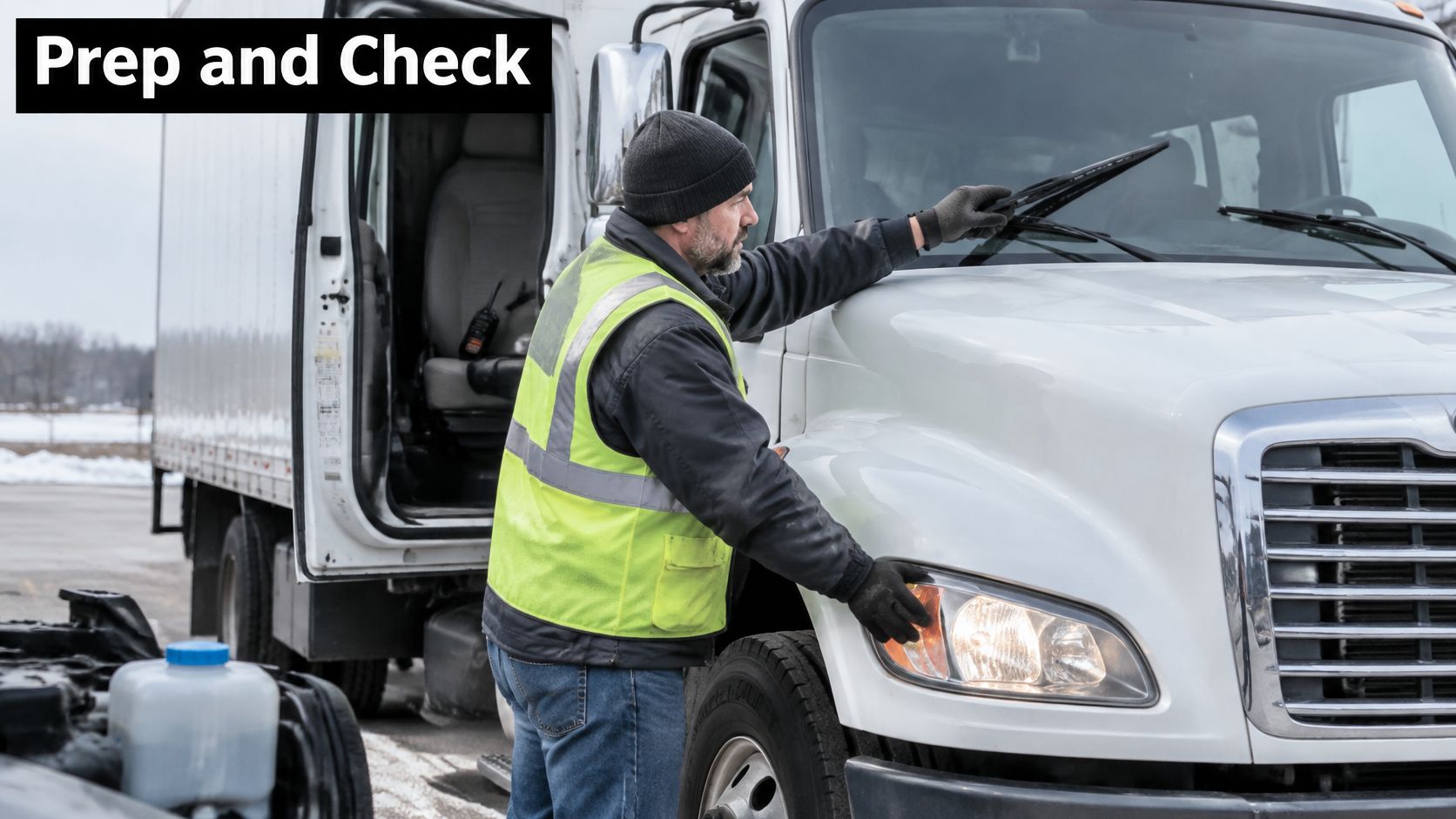
Pre-Trip Prep for a Weather Lane
Peak Transport's vehicles are inspected regularly for safety and reliability, and box truck drivers at Peak Transport load and unload with pallet jacks, document deliveries, and perform pre- and post-trip inspections. On a weather night, the driver completes the standard pre-trip, then checks the items that fail first in bad conditions.
- Wipers and washer fluid: Blades that streak in the yard will blind the driver in road spray
- Defrost and heat: A windshield that fogs from inside is a visibility loss you created yourself
- Lights: Every lamp working, lenses cleared of snow and slush
- Tires: Winter tread depth and pressure checked, chains aboard if the lane requires them
- Cleared roof: Snow and ice removed before it slides onto the windshield or following traffic
- Pallet jack: Confirmed working, because the dock load still happens in bad weather
If wipers, defrost, or tires don't pass, that's a dispatch conversation before departure, not a discovery at the second hub.
Live Monitoring Sources
Keep five feeds open during the run, each with a defined job.
- National Weather Service alerts: Warnings and advisories for the corridor, not just the origin city
- State 511 feeds: Closures, plowing status, and surface reports on the actual segments
- Pavement or RWIS readings: Surface temperature and state where sensors exist on the lane
- Fleet telematics: Speed and position plotted against planned segment times, so drift shows up early
- One shared dispatch thread: The single channel the driver and receiving hub both read
Five feeds are enough. Ten feeds produce noise, and noise at 2 a.m. produces bad calls. This monitoring rhythm sits naturally inside our established communication protocols for dispatch and drivers, so a weather night uses the same channels as a clear night, just with tighter check times.
The Dispatch Script and Check Clock
Send one message format every time. Four fields, in this order: condition, band, new ETA, and the trigger that would stop the trip. Send it to the driver and the receiving hub together, in the same thread, so nobody operates on a forwarded summary.
Check conditions on a clock, not on anxiety.
- At plan lock: Confirm the version, buffer, and trigger are written down
- 30 minutes before departure: Recheck pavement, visibility, and wind against the locked version
- At departure: Confirm the driver has the current version and the truck passed prep
- At each hub handoff: Compare actual segment times and conditions with the plan
Send a new message only when a trigger trips. A driver shouldn't have to sort forecast chatter while rolling. Silence between checks means the version still holds.
File each note under the route version it belongs to. The plan stays valid only while pavement, visibility, and wind still match the version the driver was given. After the shift, the post-trip note records whether the buffer held, which segments ran slow, and whether any trigger fired. That note feeds the next run on the same lane, so tonight's weather lesson becomes tomorrow's better buffer instead of a story nobody wrote down.
Run Tomorrow's Lanes on a Weather Plan
Tomorrow's overnight cycle starts with the lanes you already run. Peak Transport's Middle Mile Logistics service is the link between distribution centers and hubs, and our Route Optimization uses data modeling to reduce mileage and cut fuel consumption. Weather planning sharpens that existing structure. It doesn't replace it.
Pull tomorrow's facility-to-facility lanes and run each one through the buffer table. Apply the condition row that matches the forecast pavement and visibility at the driving hour, segment by segment.
Score every lane against the four go, delay, or park bands. Name the band before you discuss appointments. The band decides what's negotiable.
Lock a departure only after the predeparture recheck passes against the current route version. If the latest reading has voided the version, rebuild the plan. Don't depart on paperwork the road has already overruled.
Close the Loop With the Post-Trip Review
If a lane lands in the stop band, publish the revised ETA and the fallback plan to the driver and receiving hub before anyone leaves the yard. Then review the post-trip notes from the last cycle. Which buffers held? Which triggers fired? Which appointments moved, and did the early warning give the hub enough time to adjust?
Adjust the buffer rows for any lane where realized delay ran past the pad. A segment that consistently beats your snow buffer needs a bigger number, a treated alternate, or a later standard departure in winter. Let your own lane history correct your assumptions, one cycle at a time.
Done well, the arrival you promise is the arrival the pavement can support, and the driver still finishes the local shift with hours to spare. That's the whole point of route planning weather work on middle-mile lanes. Score the lane, write the buffer, publish the trigger, and don't depart on a version the latest reading has already voided. If you want to talk through how a lane should be scored, our office number is 612-230-1292.
Peak Transport runs overnight middle-mile box-truck lanes between distribution centers and hubs across the Twin Cities, with weather-aware planning that scores each corridor by pavement, visibility, and wind before an ETA is promised. If you need a middle-mile partner that protects driver hours, hub handoffs, and on-time performance when Minnesota weather turns, visit Peak Transport to see how our structured dispatch and route planning can support your network.